make.interpolation
make.interpolation will estimate the geometry of a landslide failure surface by interpolating between the landslide extent and user-defined xyz points. The following is typical usage for make.interpolation.
Prepare a topography file as a geotif.
Prepare a polygon reflecting the landslide extent and a set of points reflected estimated failure surface locations.
Run
make.interpolationto generate results. Inspect the output and adjust any input parameters as needed.
A code snippet that uses make.interpolation and a few other digger functions in the context of the 2025 Tracy Arm event (Shugar and othesr, 2026) may be found in the file digger/examples/pre-run/tracy_arm/tracy_arm_reconstruction.py.
"""An example of using multiple tools to reconstruct topography and
estimate a landslide slip surface.
"""

import rasterio
from rasterio.merge import merge

from digger import make
from digger.utils import interpolate

# reconstruct the bathymetry
make.interpolation(
    topo_path="../../../data/tracy_arm_topo.tif",
    mask_path="../../../data/tracy_arm_new_water.geojson",
    points_path="../../../data/tracy_arm_water_points.geojson",
    b_prefix="merged_new_water",
    sense="subtract",
    smooth=True,
    smooth_sigma=7,
    write_tt3=False,
    edge_adjustment=0,
)

interpolate.polygon(
    topo_path="merged_new_water.tif",
    mask_path="../../../data/tracy_arm_interp_shoreline.geojson",
    smooth=True,
    smooth_sigma=5,
    file_out="merged_new_water_shoreline_adj_clipped.tif",
)

# merge this into full extent:
# List the paths to the input raster files
to_merge = [
    "../../../data/tracy_arm_topo.tif",
    "merged_new_water_shoreline_adj_clipped.tif",
]
src_ds = [rasterio.open(f) for f in to_merge]

# Merge the datasets
mosaic, out_transform = merge(src_ds, method="last")

# Get the metadata from the first source dataset and update it for the output
out_meta = src_ds[0].meta.copy()
out_meta.update(
    {
        "driver": "GTiff",
        "height": mosaic.shape[1],
        "width": mosaic.shape[2],
        "transform": out_transform,
        "crs": src_ds[0].crs,
    }
)

# Write the merged raster to a new file
with rasterio.open("merged_new_water_shoreline_adj.tif", "w", **out_meta) as dest:
    dest.write(mosaic)

# Close the source datasets
for src in src_ds:
    src.close()

# Estimate the landslide slip surface
make.interpolation(
    topo_path="merged_new_water_shoreline_adj.tif",
    mask_path="../../../data/tracy_arm_source.geojson",
    points_path="../../../data/tracy_arm_ls_points.geojson",
    sense="subtract",
    write_tt3=False,
    edge_adjustment=-10,
)
After this code runs, it will produce geotif files that specify the modified topobathymetry.
It will also create diagnostic figures.
The standard two diagnostic figures from make.interpolation are
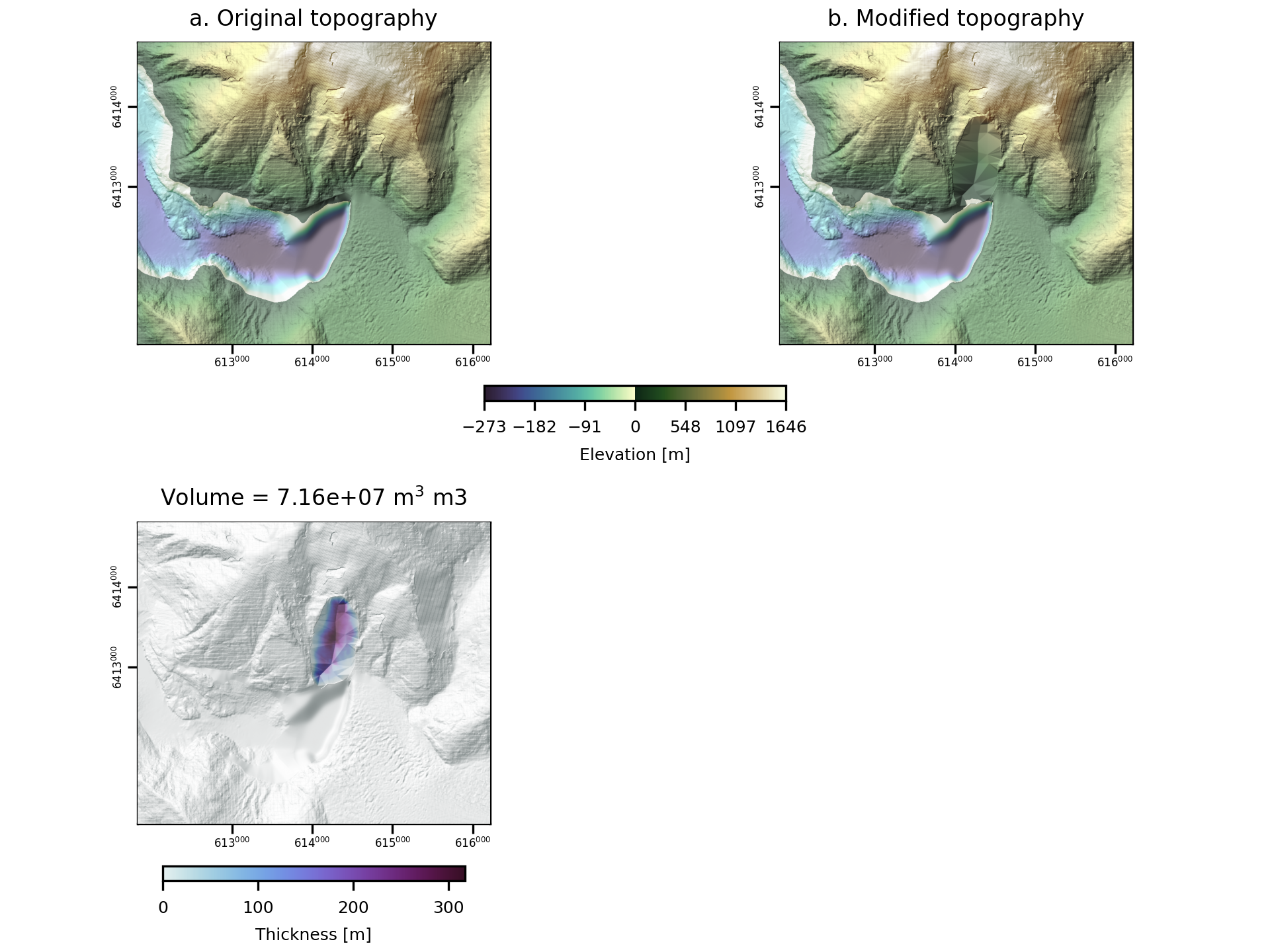
Fig. 3 An example of the diagnostic output provided by digger.make.interpolation.
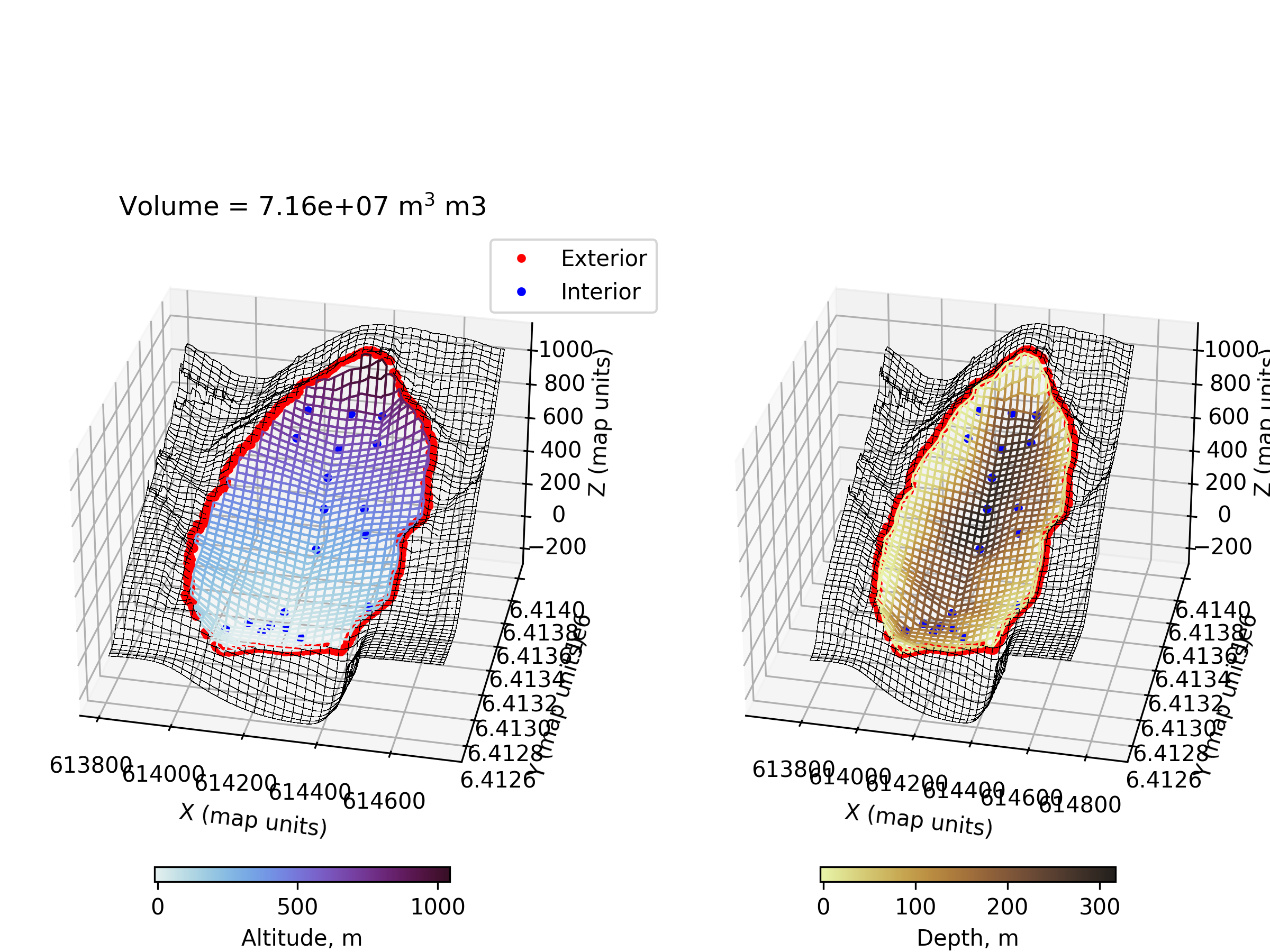
Fig. 4 An example of the diagnostic output provided by digger.make.interpolation.
References
Shugar, D.H., Barnhart, K.R., Berdahl, M., Caplan-Auerbach, J., Ekström, G., Fathian, A., Geertsema, M., Hicks, S.P., Higman, B., Jensen, E.K., Karasözen, E., Lynett, P., Lyons, J., Monahan, T., Roe, G., Svennevig, K., Toney, L., Van Wyk De Vries, M., and West, M.E., 2026, A 481-meter-high landslide-tsunami in a cruise ship–frequented Alaska fjord: Science, https://doi.org/10.1126/science.aec3187.